LSTprecision
What is LSTprecision?
LSTprecision delivers exceptional satellite-based land surface temperature sensitivity and details, enabling accurate absolute temperature measurements. It is designed for precise thermal data, making it ideally suited for urban, vegetation, and industrial analyses with new levels of coverage, detail, and accuracy. LSTprecision also delivers co-registered accurate surface reflectance measurements across visible and near-infrared bands, day and night. This enables for example the generation of true-color imagery and the calculation of key vegetation indices providing complementary information for more robust temperature analyses. LSTprecision is built on a satellite system independently reviewed under the European Space Agency’s (ESA) Copernicus quality assessment framework. An ESA-commissioned evaluation confirms the maturity, stability, and fitness for purpose of Constellr’s land surface temperature and surface reflectance products.
When should you use LSTprecision?
- Protect high-value assets: Get asset-level insights with accurate thermal data, not just rough indices or proxies.
- Detect issues before they escalate: Our system acts as an early-warning tool, spotting stress in environments, infrastructure, and materials before damage occurs.
- Rely on unmatched temperature accuracy: With absolute precision of <2K, you can trust your data to be consistent, comparable, and reliable over time.
- See what others miss: A sensitivity of 0.03K uncovers subtle thermal shifts, ensuring confident detection of both relative and absolute changes.
- Track trends with confidence: High-frequency revisits (as often as every 3 days in daylight) deliver rich time-series data, enabling timely identification of anomalies and long-term patterns.
Want even sharper local detail? → Explore LSTzoom
Need broader, cloud-free daily coverage? → Discover LSTfusion
How is LSTprecision created?
LSTprecision is derived from the high-resolution measurements acquired by the SkyBee satellite instruments of constellr’s HiVe constellation. Following an advanced calibration and validation (cal/val) procedure, ensuring highly accurate and well georeferenced radiance data, a sequence of processing steps is applied to generate the full LSTprecision product bundle.
-
Cloud and Scene Classification: A deep learning algorithm relying on a U-net convolutional neural network (CNN)1 , classifies pixels into four cloud-related classes: clear sky, thick cloud, thin cloud, and cloud shadow. Additional masks are also generated to distinguish land and water and to detect terrain cast-shadows.
-
Atmospheric Correction Inputs: Two key atmospheric parameters are retrieved from the data:
- Aerosol Optical Thickness (AOT) using the Dense Dark Vegetation (DDV) method.
- Total Column Water Vapor (TCWV) via the Atmospheric Pre-corrected Differential Absorption (APDA) technique.
We make use of high quality and well-established datasets ERA5 and CAMS_forecast datasets to complement our imagery. We seamlessly leverage the best available source to deliver robust, reliable parameter coverage and consistently high-quality results.
-
Surface Reflectance (SR) Retrieval: Surface Reflectance is derived from the ten VNIR bands using as input the generated masks and atmospheric amounts. The constellr SR algorithm includes corrections for adjacency effects, providing SR with high accuracy for any type of scene, including vegetation, or buildings and infrastructure suitable for a large range of applications.
-
Land Surface Temperature (LST) Retrieval: The VNIR SRs are derived from the satellite footprints and used to estimate an initial (first-guess) emissivity for each of the four thermal bands (link to technology page). Those are used as input of the constellr LST algorithm, relying on the Equivalent Temperature Approach (ETA), to derive the land surface temperature and to optimize the surface emissivity’s. The simultaneous retrieval of LST and emissivity’s enhance the overall LSTprecision product accuracy.
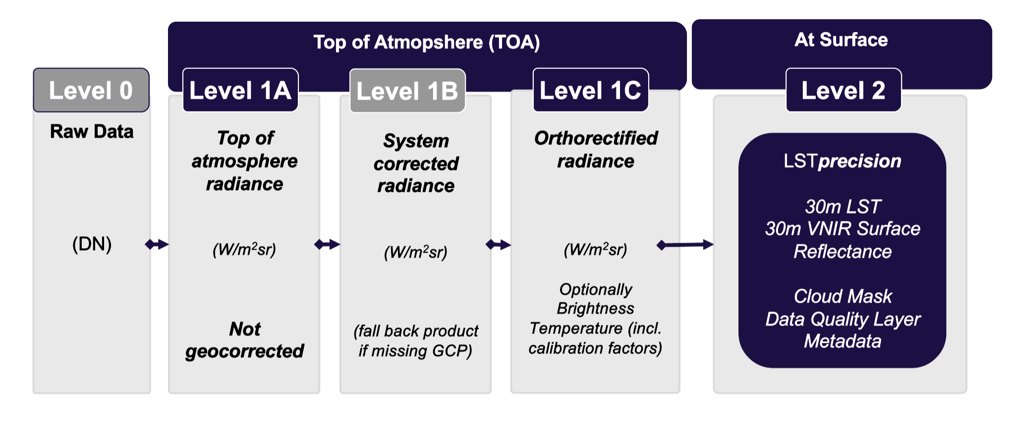
LST and VNIR surface reflectance are thus Level 2 (L2) products that have gone through various preprocessing levels (see figure below). Therefore, they represent geophysical values that are scientifically useful and that can be processed into meaningful Earth-surface variables.
During night, VNIR data are not available. Therefore, the LSTprecision Level 2 product is made exclusively of the LST layer complemented with cloud and quality masks. In the absence of SR data, the LST retrieval is adapted and initiated with a fixed emissivity value with an expected marginal accuracy loss.
What are the specifications of LSTprecision?
| Parameter | Value |
|---|---|
| Spatial Resolution | LST and SR: 30m |
| Temporal Resolution | 1.5 - 3 days |
| Output Time | 10:30 or 13:30 am and pm, local solar time |
| Coverage Area | Worldwide tasking, up to 1.000.000 km² daily imaging capacity, AOI maximum size: 15x15 km² |
| Output Format | GeoTIFF + Metadata geojson, ARD-compliant |
For more see the Technical Specifications page.
How accurate is LSTprecision?
Thanks to the robust Cal/Val approach combined with state-of-the art algorithm processors, the SkyBee data offer a high level of accuracy from the radiometric and geometric point of views. The SkyBee satellites use two cameras to capture both visible/near-infrared and thermal infrared images of Earth, similar to the capabilities of other leading observation missions. he entire calibration and validation chain behind LSTprecision has been independently reviewed as part of an ESA Copernicus mission quality assessment. This confirms that Constellr’s processing, auxiliary data usage, and validation approach meet the expectations applied to leading European Earth observation missions.
Achieving high accuracy starts well before launch with a proper characterization of the instruments in the lab and continues in space with a regular verification of the instrumental performances. Engineers monitor and correct for changes over time, detect faulty pixels, and adjust for geometric distortions using well-known landscapes and landmarks. Calibration draws on trusted ground reference sites for visible/near-infrared data and patented methods comparing thermal readings with reliable satellite temperature measurements, guaranteeing data remain precise and reliable throughout the mission. Accuracy of end-user products is also regularly evaluated against ground-truth measurements at a series of reference sites part of different official networks. These accuracy levels are supported by an independent ESA-led assessment, which confirms consistent thermal performance and reliable calibration across acquisitions.
Explore the details of our Cal/Val approach. These accuracy levels are supported bz an independent ESA-led assessment, which confirms consistent thermal performance and reliable calibration across acquisitions.
What to look forward to in future developments?
Higher revisit frequency
SkyBee-03 is already in the pipeline, with a launch scheduled for mid-2026. It will further reduce revisit times while having the high performance of our first two SkyBee instruments.
Towards a higher spatial resolution
The next generation of instruments is already in development, promising enhanced performance, such as higher native spatial resolution, to deliver even greater impact for your applications.
Last update: January, 2026
Your gateway to decoding Earth's temperature.
From pixels to planetary resilience.
Explore constellr's data, learn about thermal intelligence, explore our use cases and download actionable demo data sets.