LSTprecision Data Bundle Description
Constellr's product deliverables include several layers, which are outlined below.
Data Layers
Core product data layers
| Layers | Description | File Format |
|---|---|---|
| lst.tiff | LST data | Cloud optimized geotiff |
| quicklook.tiff | Temperature quicklook | Cloud optimized geotiff |
| thumbnail.jpg | Temperature Thumbnail | jpg |
| metadata.json | Metadata description | json |
| scl_mask_30m.tiff | Scene Classification Layer at 30m resolution | Cloud optimized geotiff |
Option 1: VNIR layers
These files are available for free for all daytime images.
| Layers | Description | File Format |
|---|---|---|
| rgb_quicklook.tiff | True color (RGB) quicklook | Cloud optimized geotiff |
| rgb_thumbnail.jpg | RGB Thumbnail | jpg |
| scl_mask_xxm.tiff | Scene Classification Layer at 10m and 20m spatial resolution | Cloud optimized geotiff |
| vnirXX.tiff1 | VNIR Surface Reflection for bands 02 - 09 (see individual band's resolution on Our Technology) | Cloud optimized geotiff |
| vnirXX_qa.tiff | Quality Assessment Layer for each VNIR band at band's spatial resolution | Cloud optimized geotiff |
Option 2: Shaprening layer
| Layers | Description | File Format |
|---|---|---|
| lst_sharpened_10m.tiff | LST data at 10m resolution | Cloud optimized geotiff |
| lst_quicklook_sharpened_10m.tiff | Temperature quicklook at 10m | Cloud optimized geotiff |
| lst_thumbnail_sharpened_10m.tiff | Temperature thumbnail at 10m | jpg |
| scl_mask_10m.tiff | Scene Classification Layer at 10m spatial resolution | Cloud optimized geotiff |
Data Layer Description
LSTprecision Layer
LSTprecision's unprecedented temperature sensitivity allows for reliable absolute temperature analysis at 30m - day and night. It is derived from the high-resolution measurements acquired by the SkyBee satellite instruments of constellr’s HiVe constellation. Following an advanced calibration and validation (cal/val) procedure, ensuring highly accurate and well georeferenced radiance data, a sequence of processing steps is applied to generate the full LSTprecision product bundle:
-
Cloud and Scene Classification: A deep learning algorithm relying on a U-net convolutional neural network (CNN), classifies pixels into four cloud-related classes: clear sky, thick cloud, thin cloud, and cloud shadow. Additional masks are also generated to distinguish land and water and to detect terrain cast-shadows.
-
Atmospheric Correction Inputs: Two key atmospheric parameters are retrieved from the data:
- Aerosol Optical Thickness (AOT) using the Dense Dark Vegetation (DDV) method.
-
Total Column Water Vapor (TCWV) via the Atmospheric Pre-corrected Differential Absorption (APDA) technique.
We make use of high quality and well-established datasets ERA5 and CAMS_forecast datasets to complement our imagery. We seamlessly leverage the best available source to deliver robust, reliable parameter coverage and consistently high-quality results.
-
Surface Reflectance (SR) Retrieval: Surface Reflectance is derived from the ten VNIR bands using as input the generated masks and atmospheric amounts. The constellr SR algorithm includes corrections for adjacency effects, providing SR with high accuracy for any type of scene, including vegetation, or buildings and infrastructure suitable for a large range of applications.
-
Land Surface Temperature (LST) Retrieval: The thermal retrieval is based on a library-constrained Temperature–Emissivity Separation (TES) approach. Instead of relying only on VNIR-derived first-guess emissivities, the algorithm evaluates candidate emissivity spectra from a spectral library that has been adapted to the sensor’s thermal bands. For each pixel, the observed thermal radiances are atmospherically corrected and compared against the candidate emissivity spectra to identify the most physically plausible emissivity-temperature combination. Candidate solutions are ranked primarily by inter-band temperature consistency, and the final emissivity is derived from the best-supported subset of candidates. This joint retrieval of LST and emissivity provides a more physically meaningful representation of surface thermal behaviour, particularly over heterogeneous and mixed land-cover types, and supports improved robustness of the final LST product.
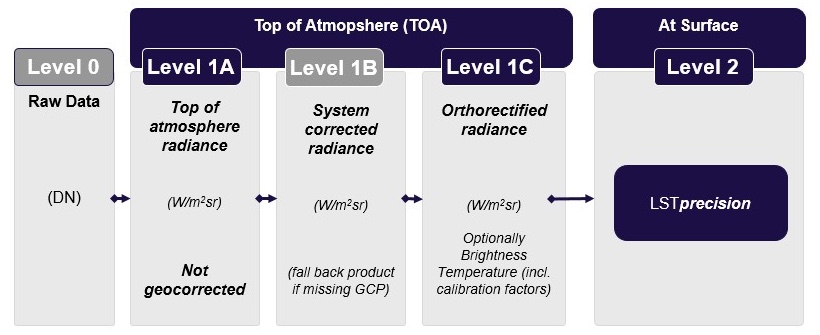
LST and VNIR surface reflectance are thus Level 2 (L2) products that have gone through various preprocessing levels (see Figure below). Therefore, they represent geophysical values that are scientifically useful and that can be processed into meaningful Earth-surface variables.
During night, VNIR data are not available. Therefore, the LSTprecision Level 2 product is made exclusively of the LST layer complemented with cloud and quality masks.
VNIR Surface Reflectance Layers
Daytime imagery comes with 8 VNIR bands. This enables the generation of true-color imagery and the calculation of key spectral indices providing complementary information for more robust temperature analyses.
Surface reflectance (SR) is delivered at 10m and 20m spatial resolution (see Our Technology for each band's resolution). The physical values of reflectance (unitless scaled between 0 and 1) can be obtained by applying the offset and scale factors, as specified in the table below, following:
\({SR} = DN * scale factor + offset\)
This has been introduced to allow the quantization of floating point numbers up to 1/100% in a 16 bit integer number. The offset value is non-zero to ensure that slightly negative values are not clipped. The product is based on the L1B/C product and shows the same geotiff structure as the L1B/C radiance files.
Quality Assessment Layers
Quality masks are provided for each of the VNIR and TIR bands as uint8 data at the native spatial resolution of the corresponding band. Those masks report among others the presence of saturated pixels, nodata pixels, or possibly pixels for which the quality could not be tested.
Scene Classification Layers
The Scene Classification Layer (SCL) provides per-pixel quality and contextual information that can be used to identify and mask clouds, cloud shadows, and water bodies, enabling more robust retrieval of geophysical parameters and improving the reliability of change detection, time-series analysis, and monitoring workflows.
The SCL product consists of four classification bands: a cloud mask, a cast shadow mask, a dynamic and a static land/water mask (see more detail in Metadata).
The dynamic land/water mask is generated from the Level-1B calibrated (L1BC) imagery using the spectral ratio between the VNIR03 and VNIR08 bands. This approach leverages the characteristic reflectance differences of water and land surfaces to derive a scene-dependent classification that captures temporary changes in coastlines, water extent, and surface conditions at the time of acquisition.
The static land/water mask is derived from the ESA WorldCover 2021 global land-cover dataset and provides a stable reference classification independent of the current acquisition. It is particularly useful for consistency checks and for distinguishing between persistent land/water boundaries and short-term variations observed in the dynamic mask.
Sharpening Layer
The sharpening layer has a 10m spatial resolution that can provide insights with a 10x improvement in sharpness over today's LST standard.
The sharpening algorithm creates a 10m resolution LST data layer using as input the nominal HiVE 30m LST data. It is based on the Residual-in-Residual Dense Block (RRDB) network trained using the external HyTEST Land Surface Temperature data sets. It operates without need for any auxiliary guiding bands, relying solely on thermal information. The model is optimized to ensure maintaining pixel accuracy, structural consistency, and edge preservation.
Consequently, the 10m sharpened layer provides super-resolved LST products that preserve both the absolute thermal values and the spatial patterns necessary for downstream applications.
| Variable | Data Type | Scale Factor | Offset | Unit | Fill in |
|---|---|---|---|---|---|
| ST | uint16 | 0.01 | 0 | K | 65535 |
| SR | uint16 | 0.0001 | -0.1 | 1 | 65535 |
Naming Convention
Via the API
Files can be downloaded via a STAC compliant API. The naming convention per file is as follows:
Naming convention
[Product Type] _ [Satellite ID] _ [Geohash] _ [Acquisition Time] _ [File Type]
[Product Type] = the constellr product name e.g. LSTprecision
[Satellite ID] = the unique satellite ID e.g. SBA01 or SBA02
[Geohash] = the geohash of the image’s footprint
[Acquisition Time] = the time the image was acquired by the satellite
[File Type] = describes the content of the file e.g. metadata.json, lst.tiff etc
Via the UI
For every acquired image, you can download a zip folder containing all of the files related to that image. The file naming convention is as above. The folder name is the root of the file i.e.
Naming convention
[Product Type] _ [Satellite ID] _ [Geohash] _ [Acquisition Time]
Last update: June, 2026
-
Band 01 and 10 are excluded, as they do not represent surface information. ↩